Kansas Map

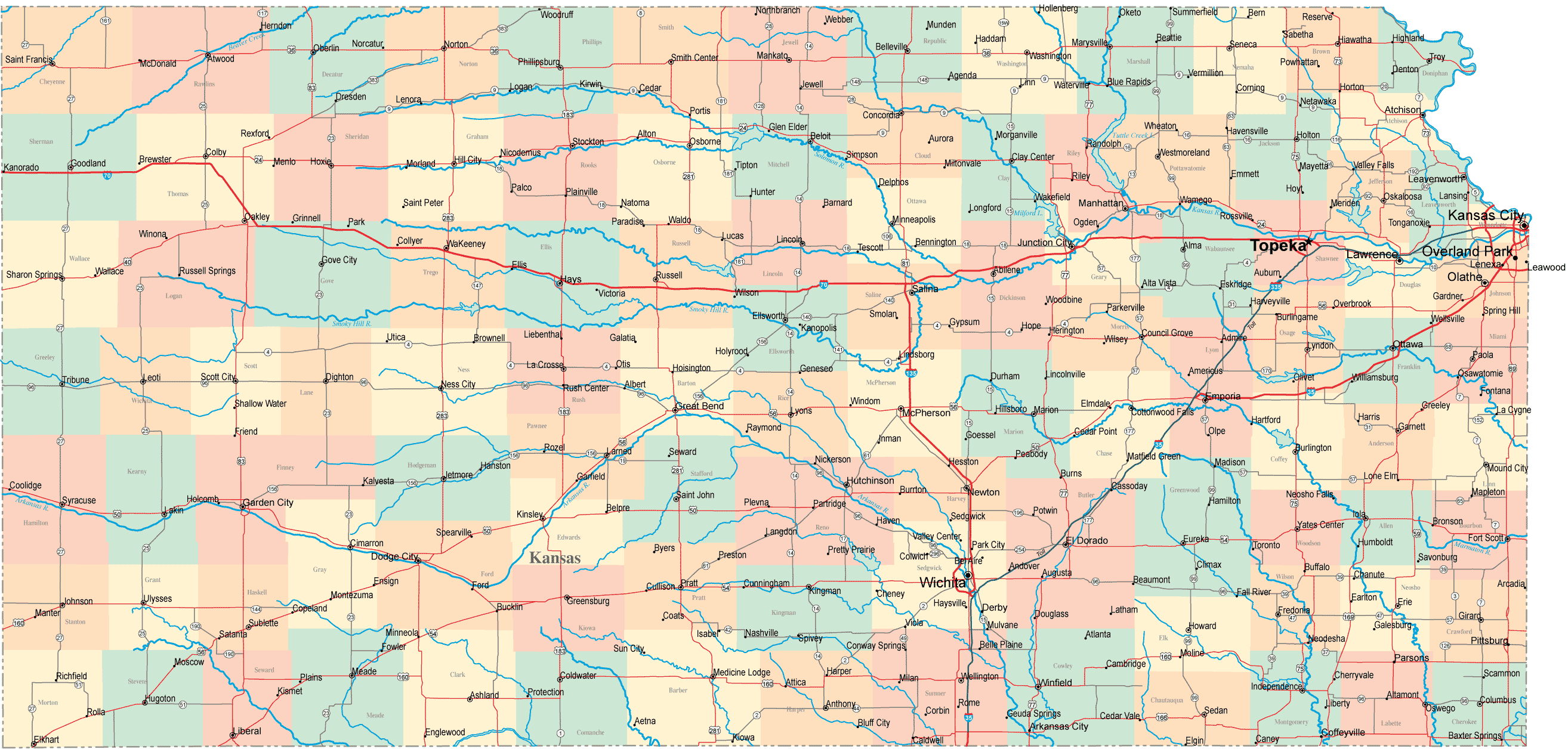
Explore the state of Kansas with our detailed map featuring cities, highways, and topographic features. Discover popular tourist destinations and landmarks, such as Wichita, Topeka, and the Flint Hills. Plan your next adventure in the Sunflower State with WorldMap1's Kansas map.
Kansas, also known as the Sunflower State, is located in the heart of the United States and is known for its vast prairies, scenic Flint Hills, and rich history. Our detailed map of Kansas is designed to help you explore and navigate this fascinating state, whether you are a resident, a visitor, or simply interested in learning more about Kansas.

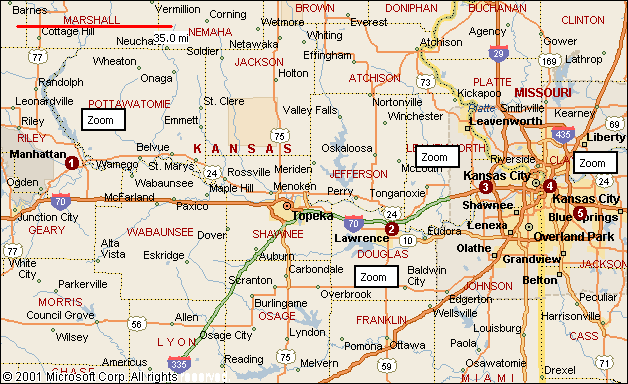
On this page, you'll find a comprehensive map that highlights the state's major cities, highways, and topographic features. You'll also discover useful information about popular tourist destinations and landmarks, including Wichita, Topeka, and the Kansas City metropolitan area. Whether you're planning a road trip, looking for new places to visit, or simply want to learn more about Kansas, WorldMap1's Kansas map has got you covered. So, let's get started and discover all the wonders that this great state has to offer!

For all Kansas Cities Map

MAP OF KANSAS
map of Kansas
WorldMap1.com Donwload Now

KANSAS CITIES TOWNS MAP

kansas cities towns map
WorldMap1.com Donwload Now

Brief information about Kansas, US

Kansas is a state located in the Midwestern region of the United States. It is bordered by Nebraska to the north, Missouri to the east, Oklahoma to the south, and Colorado to the west. With an area of approximately 82,000 square miles (213,000 square kilometers), Kansas is the 15th largest state in the US. The state's capital is Topeka, and its largest city is Wichita.

Kansas has a population of over 2.9 million people, with a majority living in urban areas such as Wichita, Overland Park, and Kansas City. The state has a diverse economy, with major industries including aviation, agriculture, manufacturing, and healthcare. Kansas is also known for its iconic landmarks, such as the Flint Hills, the Tallgrass Prairie National Preserve, and the Eisenhower Presidential Library and Museum.

Kansas played a significant role in US history, particularly during the Civil War and the era of westward expansion. The state was a crucial battleground in the fight over slavery, and many famous figures, such as abolitionist John Brown and Wild West legend Wyatt Earp, have ties to Kansas. Today, the state continues to celebrate its unique heritage and culture, with numerous museums, festivals, and historic sites.

Here's some statistical information about the area, population, demographics, history, and economy of Kansas:

Area: 82,278 square miles (213,100 square kilometers)

Population (2020 estimate): 2,937,880

Largest cities (2020 estimate):
  • Wichita: 395,745
  • Overland Park: 194,759
  • Kansas City: 150,082
  • Topeka: 125,190
  • Olathe: 142,841
Median age (2019 estimate): 37.9 years

Racial/ethnic composition (2019 estimate):
  • White: 84.8%
  • Black or African American: 6.2%
  • Hispanic or Latino: 12.0%
  • Asian: 3.1%
  • Native American: 1.2%
Historical highlights: Kansas played a pivotal role in the abolitionist movement and the Civil War. It was the site of the infamous 1856 raid by abolitionist John Brown on the pro-slavery settlement of Pottawatomie Creek, as well as the 1861 Battle of Wilson's Creek, one of the first major battles of the war. Kansas was also a key destination for settlers during the westward expansion of the 19th century, with the famous Oregon Trail and Santa Fe Trail passing through the state.

Economy: Major industries in Kansas include aerospace, agriculture, manufacturing, and healthcare. The state is home to several major aerospace companies, including Spirit AeroSystems, Textron Aviation, and Bombardier Aerospace. Agriculture is a major contributor to the state's economy, with Kansas ranking among the top producers of wheat, corn, and cattle in the US. In recent years, Kansas has also seen growth in sectors such as renewable energy, technology, and logistics.

A Collection of Kansas Maps and Kansas Satellite Images

MAP OF KANSAS

map of Kansas
WorldMap1.com Donwload Now

KANSAS CITIES MAP

kansas cities map
WorldMap1.com Donwload Now

KANSAS CITIES MAP

Kansas cities map
WorldMap1.com Donwload Now

KANSAS CITIES TOWNS MAP

kansas cities towns map
WorldMap1.com Donwload Now

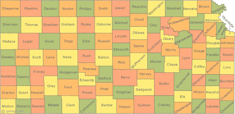
KANSAS COUNTY MAP

kansas county map
WorldMap1.com Donwload Now

KANSAS POLITICAL MAP

kansas political map
WorldMap1.com Donwload Now

KANSAS REFERENCE MAP

kansas reference map
WorldMap1.com Donwload Now

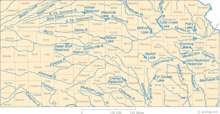
KANSAS RIVERS MAP

kansas rivers map
WorldMap1.com Donwload Now

KANSAS ROAD MAP

Kansas road map
WorldMap1.com Donwload Now

MAP OF KANSAS CITIES

map of kansas cities
WorldMap1.com Donwload Now

A collection of Kansas Maps


Author: Arif Cagrici

Largest Cities Map of Kansas and Population

Wichita Map - 382,368
Overland Park Map - 173,372
Kansas City Map - 145,786
Topeka Map - 127,473
Olathe Map - 125,872
Lawrence Map - 87,643
Shawnee Map - 62,209
Manhattan Map - 52,281
Lenexa Map - 48,190
Salina Map - 47,707
Hutchinson Map - 42,080
Leavenworth Map - 35,251
Leawood Map - 31,867
Dodge City Map - 27,340
Garden City Map - 26,658