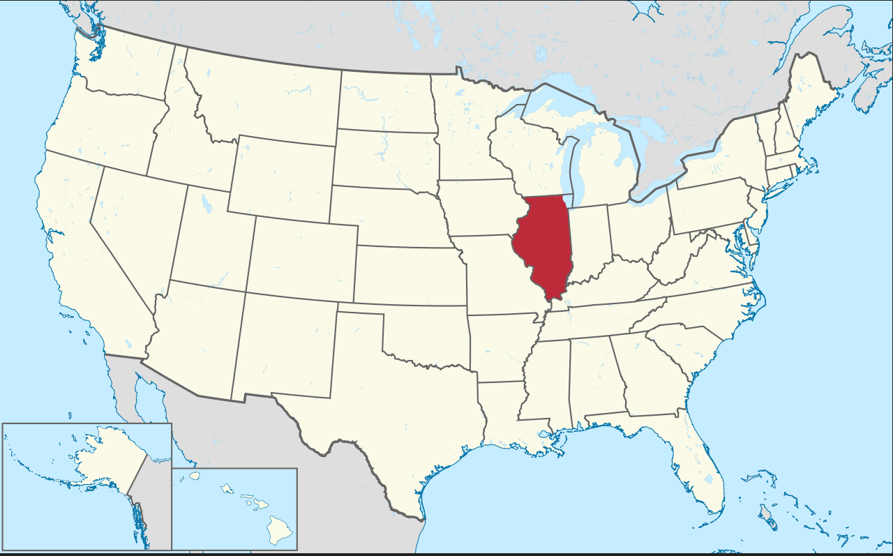
Illinois Map in United States
Illinois is a state in the Midwestern United States. Illinois is the 5th most populous state and 25th largest state in terms of land area, and is often noted as a microcosm of the entire USA. With Chicago in the northeast, small industrial cities and great agricultural productivity in central and northern Illinois, and natural resources like coal, timber, and petroleum in the south, Illinois has a diverse economic base and is a major transportation hub.
Where is Illinois in the US and Cities Map of Illinois
Please subscribe on "World Guide" channnel on Youtube at youtube.com/c/WorldGuide
Largest Cities Map of Illinois and Population
- Chicago Map - 2.695.598 - (41.878114, -87.629798)
- Aurora Map - 197.899 - (41.761,-88.32)
- Rockford Map - 152.871 - (42.271,-89.094)
- Joliet Map - 147.433 - (41.525,-88.082)
- Naperville Map - 141.853 - (41.786,-88.147)
- Springfield Map - 116.250 - (39.802,-89.644)
- Peoria Map - 115.007 - (40.694,-89.589)
- Elgin Map - 108.188 - (42.037,-88.281)
- Waukegan Map - 89.078 - (42.364,-87.845)
- Cicero Map - 83.891 - (41.84558770000,-87.75394480000)
- Champaign Map - 81.055 - (40.116420, -88.243383)
- Bloomington Map - 76.610 - (40.484203, -88.993687)
- Decatur Map - 76.122 - (39.840315, -88.954800)
- Arlington Heights Map - 75.101 - (42.088360, -87.980626)
- Evanston Map - 74.486 - (42.041141, -87.690059)
- Schaumburg Map - 74.227 - (42.033361, -88.083406)
- Bolingbrook Map - 73.366 - (41.698642, -88.068395)
- Palatine Map - 68.557 - (42.110304, -88.034240)
- Skokie Map - 64.784 - (42.033364, -87.733393)
- Des Plaines Map - 58.364 - (42.033362, -87.883399)
- Head of Performance Marketing
- Head of SEO
- Linkedin Profile: linkedin.com/in/arifcagrici
- Head of Performance Marketing
- Head of SEO
- Linkedin Profile: linkedin.com/in/arifcagrici
Google Map, Street Views, Maps Directions, Satellite Images
WorldMap1.com offers a collection of map, google map, atlas, political, physical, satellite view, country infos, cities map and more map of .
Copyright WorldMap1.com 2006 - 2023. All rights reserved. Privacy Policy | Disclaimer