Map of South Dakota is one of the most beautiful and historic states in the United States. This map provides a detailed overview of the state's geography, including its major cities, highways, and topography.
South Dakota is known for its stunning natural beauty, including the Black Hills, Badlands National Park, and the Missouri River. The state is also home to several vibrant cities, including Sioux Falls, Rapid City, and Pierre, the state capital.
One of South Dakota's most famous landmarks is Mount Rushmore, a massive sculpture depicting the faces of four US presidents carved into the granite mountainside. Other popular attractions include the Crazy Horse Memorial, the Corn Palace, and the historic town of Deadwood.
South Dakota has a rich history, with a strong Native American heritage and a key role in westward expansion during the 19th century. The state's economy is based on agriculture, tourism, and healthcare, and it is also home to several important military installations.
Whether you're planning a trip to South Dakota, researching a school project, or simply interested in exploring this beautiful state, WorldMap1's interactive map is the perfect resource to guide you on your journey.
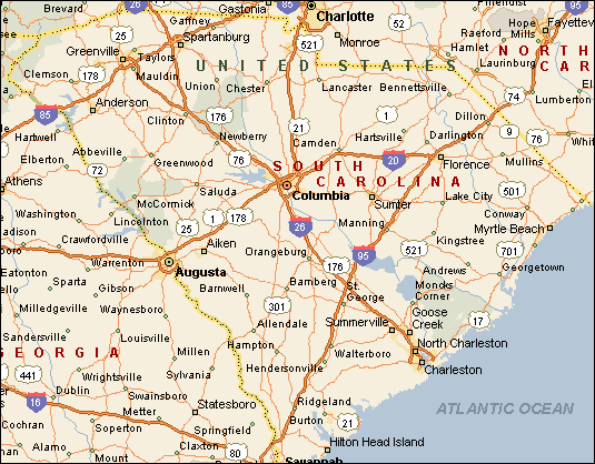
MAP OF SOUTH CAROLINA

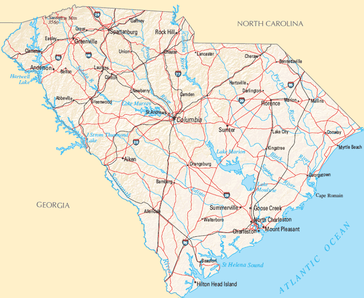
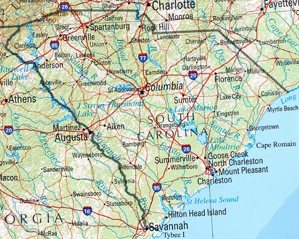
SOUTH CAROLINA REFERENCE MAP
Brief information about South Dakota, US
South Dakota is a state located in the Midwestern region of the United States. With an area of approximately 77,116 square miles (199,729 square kilometers), it is the 17th largest state in the country. As of 2020, South Dakota has an estimated population of approximately 886,667 people, making it one of the least populous states in the US.
The state of South Dakota is home to a diverse range of landscapes, from the rugged Badlands to the rolling plains and fertile farmland. The Missouri River, which runs through the state, is an important source of water for irrigation, transportation, and recreation.
South Dakota has a rich cultural history, with a strong Native American heritage and a key role in westward expansion during the 19th century. The state is home to several important landmarks and historic sites, including Mount Rushmore, the Crazy Horse Memorial, and the ghost town of Deadwood.
Agriculture is the largest industry in South Dakota, with crops such as corn, soybeans, and wheat being major contributors to the state's economy. Tourism is also an important industry, with visitors coming to explore the state's natural beauty and historic landmarks. Other important sectors include healthcare, manufacturing, and finance.
Overall, South Dakota is known for its stunning landscapes, rich history, and friendly people. Whether you're interested in outdoor activities, history, or simply exploring a new part of the country, South Dakota has something for everyone.
Demographics: South Dakota is predominantly White (82.5%), with Native Americans comprising the largest minority group (9.9%). Other minority groups include Hispanic/Latinos (4.6%) and African Americans (1.8%).
History: South Dakota has a rich Native American history, with several tribes, including the Sioux, living in the region for thousands of years. The state played a key role in westward expansion during the 19th century, with the Lewis and Clark Expedition and the Gold Rush of 1876 bringing settlers to the area. In the 20th century, the state was the site of several important military installations, including the Ellsworth Air Force Base and the Minuteman Missile National Historic Site.
Economy: The largest industry in South Dakota is agriculture, with crops such as corn, soybeans, and wheat being major contributors to the state's economy. Other important sectors include tourism, healthcare, manufacturing, and finance. The state has a low unemployment rate and is known for its business-friendly policies, which have attracted several large corporations to the area. Major companies with operations in South Dakota include Wells Fargo, Citibank, and Capital One.
A Collection of South Carolina Maps and South Carolina Satellite Images
MAP OF SOUTH CAROLINA
SOUTH CAROLINA MAP
SOUTH CAROLINA MAP

SOUTH CAROLINA REFERENCE MAP
SOUTH CAROLINA CITIES MAP

SOUTH CAROLINA COUNTY MAP

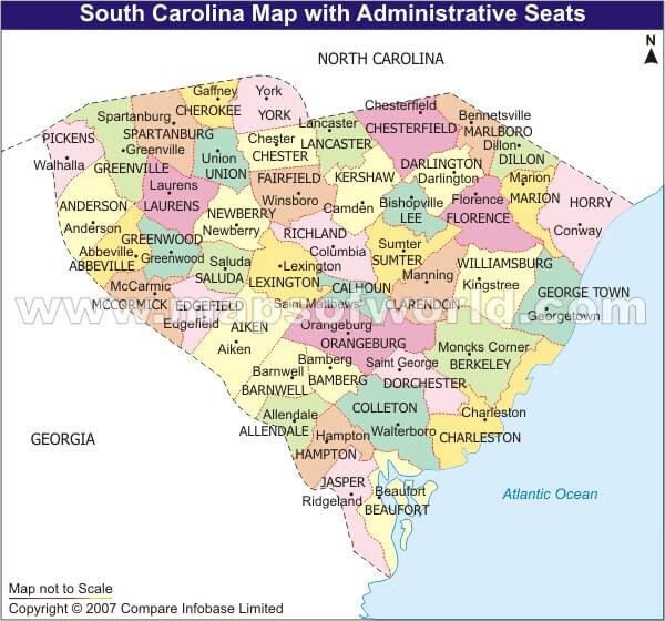
SOUTH CAROLINA COUNTY SEAT MAP
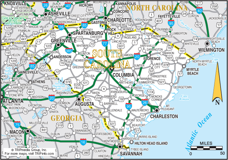
SOUTH CAROLINA HIGWAYS MAP

SOUTH CAROLINA HISTORICAL MAP

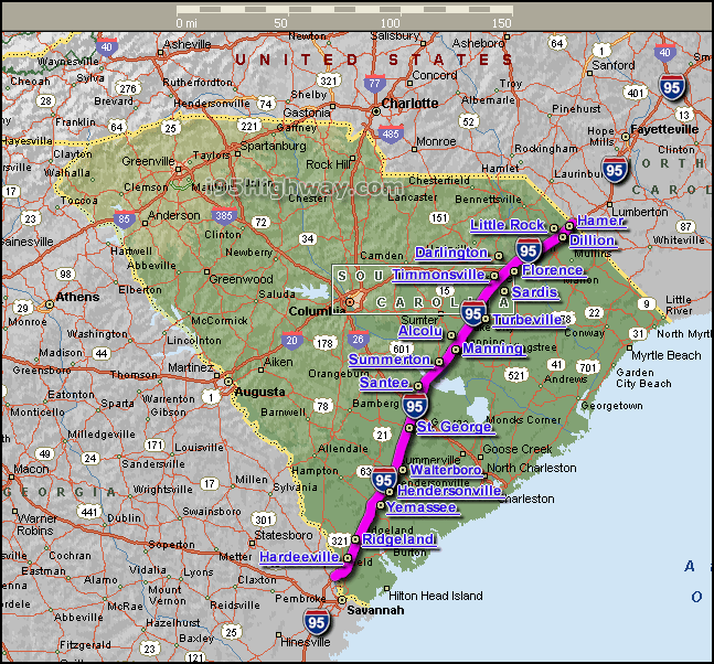
SOUTH CAROLINA INTERSTATE 95 MAP
SOUTH CAROLINA MAP

SOUTH CAROLINA MAPS
SOUTH CAROLINA POLITICAL MAP

SOUTH CAROLINA POPULATION MAP

SOUTH CAROLINA RAIL ROAD MAP

SOUTH CAROLINA ROAD MAP

SOUTH CAROLINA ROUTE MAP

SOUTH CAROLINA SATELLITE MAP

SOUTH CAROLINA STATE MAP
A collection of South Carolina Maps
Author: Arif Cagrici
