Check Out North America Maps 🌵 Learn more about the countries and cities of North America 🌉
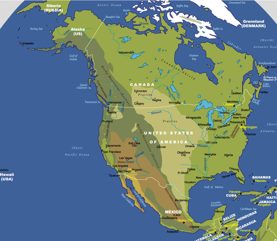
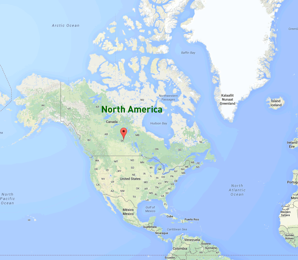
North America is a continent located in the Northern Hemisphere and is bordered by the Arctic Ocean to the north, the Atlantic Ocean to the east, and the Pacific Ocean to the west. It is made up of 23 countries, including the United States, Canada, Mexico, Cuba, Haiti Dominican Republic, Jamaica, and Central America, and the Caribbean islands. North America is a diverse continent with a wide range of physical features, including mountains, forests, deserts, and rivers.
With interactive North America Map, view regional highways maps, road situations, transportation, lodging guide, geographical map, physical maps and more information. On North America Map, you can view all states, regions, cities, towns, districts, avenues, streets and popular centers' satellite, sketch and terrain maps.
What are some facts about North America
- Area: 24,709,000 km2 (9,540,000 sq mi)
- Population: 592,296,233 (2021)
- Population Density: 72.9/km2 (188/sq mi)
- GDP (nominal): $29 trillion (2022 est)
- GDP per capita: $57,410 (2022 est.)
- Religions:
Christianity (74.6%)
No religion (19.2%)
Judaism (1.6%)
Islam (1.3%)
Hinduism (1.2%) - Largest Cities:
Mexico City
New York City
Los Angeles
Chicago
Boston
Toronto
Dallas–Fort Worth
San Francisco Bay Area
Houston
Miami
Philadelphia
Map of North America
Where is North America in the World?

North America Satellite Image

US Mexico Caribbean Islands Satellite Map

North America Maps, Countries Map and Earth Views from Space
Please subscribe on "World Guide" channnel on Youtube at youtube.com/c/WorldGuide
World Countries National Boundaries Map with Flags

Please view more North America Countries' Maps
For more North America maps; Map of North America
North America Countries Map
Anguilla Map Antigua and Barbuda Map Aruba Map Bahamas Map Barbados Map Belize Map Bermuda Map Canada Map Cayman Islands Map Cocos Islands Map Costa Rica Map Cuba Map Dominica Map Dominican Republic Map El Salvador Map Grenada Map Guatemala Map Haiti Map Honduras Map Jamaica Map North America Map Saint Vincent and the Grenadines Map Trinidad and Tobago Map Turks and Caicos Islands Map United States Map British Virgin Islands Map US Virgin Islands Map Mexico Map Montserrat Map Netherlands Antilles Map Nicaragua Map Panama Map Puerto Rico Map Saint Barthelemy Map Saint Kitts and Nevis Map Saint Lucia Map Saint Martin Map Saint Pierre and Miquelon Map Central America MapThe United States
 The United States is a federal constitutional republic comprising fifty states and a federal district. The country is situated mostly in central North America, where its forty-eight contiguous states and Washington, D.C., the capital district, lie between the Pacific and Atlantic Oceans, bordered by Canada to the north and Mexico to the south. Alaska is west of Canada and east of Russia across the Bering Strait; Hawaii is in the mid-Pacific. The state of Alaska is in northwest North America (Canada to west; Russia to east) between Yukon Territory (Canada) on north & British Columbia (Canada) on south .
Canada
 Canada is a country in the northern part of North America. It extends from the Atlantic Ocean in the east to the Pacific Ocean in the west and northward into arctic waters. With 9,984,670 km2 of total land area, Canada is slightly larger than France and Spain combined with their respective total areas (which are about 643,000 km2 and 505,000 km2 respectively). The size of its land mass has been compared to that of Russia (17 million square kilometers) or India (3.3 million square kilometers). It shares borders with three contiguous US states: Washington, Idaho and Montana as well as four non-contiguous U.S states: Alaska; Hawaii; Maine; New York City/Staten Island.
Mexico
 Mexico is the largest country in North America and it covers more than one third of the continent.
The Bahamas
 The Bahamas is a Caribbean Island country, located in the Atlantic Ocean, southeast of Florida.
Cuba
 The Cuban island of Cuba is located in the Caribbean Sea and has a tropical climate. Its capital city is Havana, which sits on the north coast of Cuba along its narrowest point between the Gulf of Mexico and Atlantic Ocean. The island nation has countless natural sites to visit and activities to enjoy, including beaches, caves and mountains.
Haiti
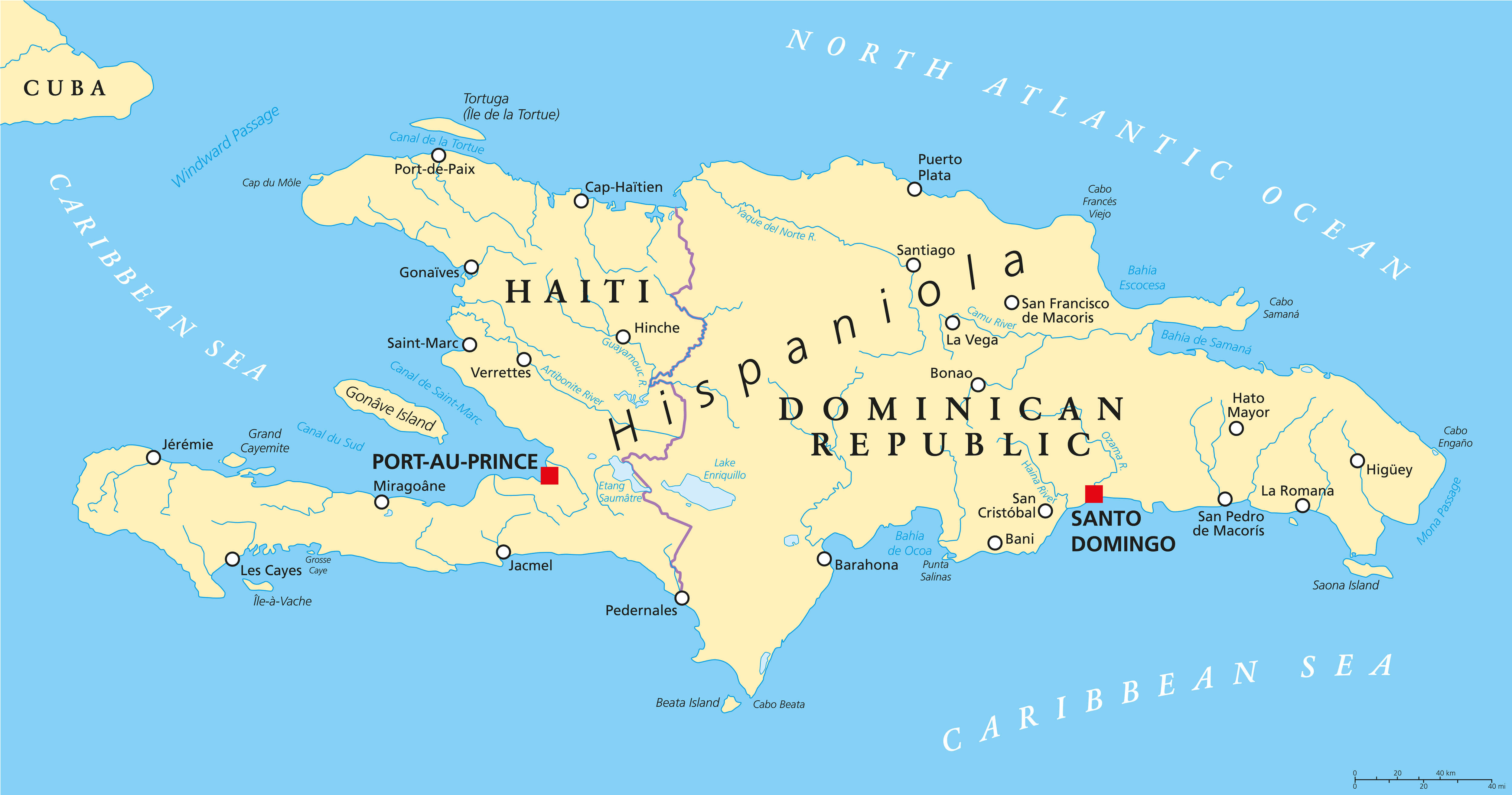 Haiti is a country located on the island of Hispaniola, which also shares its borders with the Dominican Republic. The capital and largest city is Port-au-Prince.
Dominican Republic
 Dominican Republic is a sovereign island nation located in the eastern Caribbean Sea, south-southeast of Guadeloupe and northwest of Martinique.
Puerto Rico
 Puerto Rico is an island that is a territory of the United States. It is the most densely populated of the islands of the Caribbean, and it has a wide range of natural resources, such as fish and minerals. Its capital city is San Juan, which has been named one of America's top 10 cities to visit by National Geographic Traveler magazine.
Jamaica
 Jamaica is an island nation in the Caribbean Sea. Jamaica is the third largest island in the Caribbean, after Cuba and Hispaniola. It lies about 1,000 kilometres (620 mi) south of Miami, Florida, 800 kilometres (500 mi) southwest of Haiti and 400 km west of the Central American country Belize.
A Collection of North America Maps and North America Satellite Images
map of north america

color blank map of north america.

countries in north america

early man coming to america map 8000 bc

languages map of americas 2009

map of north america

native languages map of north america

native languages of north america map

non native american nations control map 1750

North America Earth Map

north america map

north america map

north america maps

north america political map

north america satellite image

north america blank map

north america cities map

north america google map
north america historical map 1845

north america koppen map

north america map

north america map

north america map blank

north america map canada

north america map continent

north america map countries

north america map in 1888

north america map mexico

north america map us

north america map us cities

north america map us states

north america map world

north america maps

north america native american map

north america outline map

north america physical blank map

north america physical map

north america physical map blank

north america physical map countries

north america physical map from space

north america physical map with countries

north america physical map with coutries

north america pipelines map

north america political map

north america political map

north america political map countries

north america political map world

north america population map

north america satellite image

north america satellite image map

north america satellite map

north america water divides map

north central america physical map

pan ameircan highway map north south america

structural geology of north america map 2003

tectonic structure of north america

vegetation map of north america

where is north america in the world
where is moraine lake canada

where is north america in the world

- Head of Performance Marketing
- Head of SEO
- Linkedin Profile: linkedin.com/in/arifcagrici
Top 50 Largest Cities Map in the World by Country and Rank Population
- 1. Tokyo , Japan - 32,450,000
- 2. Seoul Map , South Korea - 20,550,000
- 3. Mexico City , Mexico - 20,450,000
- 4. New York, USA - 19,750,000
- 5. Mumbai , India - 19,200,000
- 6. Jakarta , Indonesia - 18,900,000
- 7. Sao Paulo , Brazil - 18,850,000
- 8. Delhi , India - 18,680,000
- 9. Osaka , Japan - 17,350,000
- 10. Shanghai , China - 16,650,000
- 11. Manila , Philippines - 16,300,000
- 12. Los Angeles, USA - 15,250,000
- 13. Calcutta , India - 15,100,000
- 14. Moscow , Russia - 15,000,000
- 15. Cairo , Egypt - 14,450,000
- 16. Lagos , Nigeria - 13,488,000
- 17. Buenos Aires , Argentina - 13,170,000
- 18. London , United Kingdom - 12,875,000
- 19. Beijing , China - 12,500,000
- 20. Karachi , Pakistan - 11,800,000
- 21. Dhaka , Bangladesh - 10,979,000
- 22. Rio de Janeiro , Brazil - 10,556,000
- 23. Tianjin , China - 10,239,000
- 24. Paris , France - 9,638,000
- 25. Istanbul , Turkey - 9,413,000
- 26. Lima , Peru - 7,443,000
- 27. Tehran , Iran - 7,380,000
- 28. Bangkok , Thailand - 7,221,000
- 29. Chicago , United States - 6,945,000
- 30. Bogota , Colombia - 6,834,000
- 31. Hyderabad , India - 6,833,000
- 32. Chennai , India - 6,639,000
- 33. Essen , Germany - 6,559,000
- 34. Ho Chi Minh , Vietnam - 6,424,519
- 35. Hangzhou , China - 6,389,000
- 36. Hong Kong , China - 6,097,000
- 37. Lahore , Pakistan - 6,030,000
- 38. Shenyang , China - 5,681,000
- 39. Changchun , China - 5,566,000
- 40. Bangalore , India - 5,544,000
- 41. Harbin , China - 5,475,000
- 42. Chengdu , China - 5,293,000
- 43. Santiago , Chile - 5,261,000
- 44. Guangzhou , China - 5,162,000
- 45. St. Petersburg , Russia - 5,132,000
- 46. Kinshasa , Democratic Republic Congo - 5,068,000
- 47. Baghdad , Iraq - 4,796,000
- 48. Jinan , China - 4,789,000
- 49. Houston , United States of America - 4,750,000
- 50. Toronto , Canada - 4,657,000