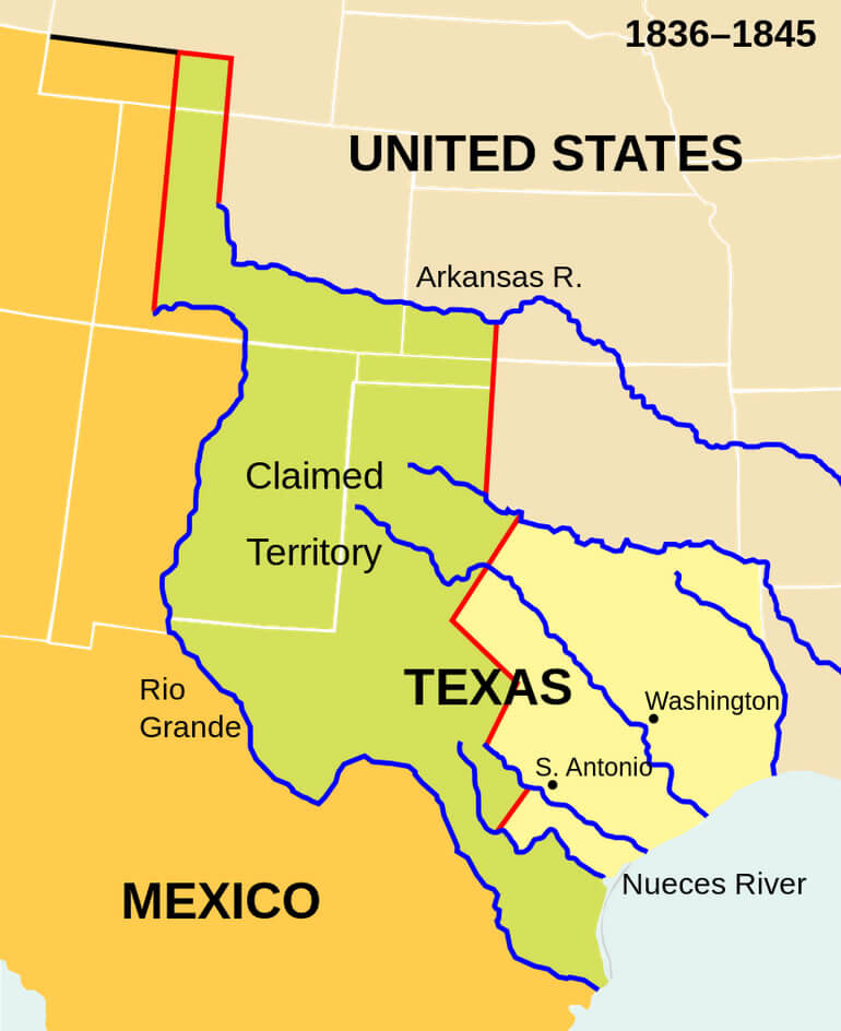
Republic of Texas Map USA 1836 1845
Republic of Texas. The present-day outlines of the U.S. states superimposed on the boundaries of 1836–1845.
Click for Content Detail »
Largest Cities Map of Texas and Population
- Houston Map - 2.099.451 - (29.760193, -95.369390)
- San Antonio Map - 1.327.407 - (29.424 / -98.494)
- Dallas Map - 1.197.816 - (32.783 / -96.807)
- Austin Map - 790.390 - (30.267 / -97.743)
- Fort Worth Map - 741.206 - (32.725 / -97.321)
- El Paso Map - 649.121 - (31.759 / -106.487)
- Arlington Map - 365.438 - (32.736 / -97.108)
- Corpus Christi Map - 305.215 - (27.801 / -97.396)
- Plano Map - 259.841 - (33.02 / -96.699)
- Laredo Map - 236.091 - (27.506 / -99.508)
- Lubbock Map - 229.573 - (33.577863, -101.855166)
- Garland Map - 226.876 - (32.912624, -96.638883)
- Irving Map - 216.290 - (32.814018, -96.948894)
- Amarillo Map - 190.695 - (35.221997, -101.831297)
- Grand Prairie Map - 175.396 - (32.745964, -96.997785)
- Brownsville Map - 175.023 - (25.901747, -97.497484)
- Pasadena Map - 149.043 - (29.691063, -95.209101)
- Mesquite Map - 139.824 - (32.766796, -96.599159)
- McKinney Map - 131.117 - (33.197246, -96.639782)
- McAllen Map - 129.877 - (26.203407, -98.230012)
- Killeen Map - 127.921 - (31.117119, -97.727796)
- Waco Map - 124.805 - (31.549333, -97.146670)
- Carrollton Map - 119.097 - (32.975642, -96.889964)
- Beaumont Map - 118.296 - (30.080174, -94.126556)
- Abilene Map - 117.063 - (32.448736, -99.733144)
- Frisco Map - 116.989 - (33.150674, -96.823612)
- Denton Map - 113.383 - (33.214841, -97.133068)
- Midland Map - 111.147 - (31.997346, -102.077915)
- Wichita Falls Map - 104.553 - (33.913708, -98.493387)
- Odessa Map - 99.940 - (31.845682, -102.367643)
- Round Rock Map - 99.887 - (30.508255, -97.678896)
- Richardson Map - 99.223 - (32.948179, -96.729720)
- Tyler Map - 96.900 - (32.351260, -95.301062)
- Lewisville Map - 95.290 - (33.046233, -96.994174)
- College Station Map - 93.857 - (30.627977, -96.334407)
- The Woodlands Map - 93.847 - (30.165821, -95.461263)
- San Angelo Map - 93.200 - (31.463772, -100.437038)
- Pearland Map - 91.252 - (29.563567, -95.286047)
- Allen Map - 84.246 - (33.103174, -96.670550)
- League City Map - 83.560 - (29.507454, -95.094930)
- Longview Map - 80.455 - (32.500704, -94.740489)
- Sugar Land Map - 78.817 - (29.619679, -95.634946)
- Edinburg Map - 77.100 - (26.301737, -98.163343)
- Mission Map - 77.058 - (26.215907, -98.325293)
- Bryan Map - 76.201 - (30.674364, -96.369963)
- Baytown Map - 71.802 - (29.735505, -94.977427)
- Pharr Map - 70.400 - (26.194796, -98.183622)
- Missouri City Map - 67.358 - (29.618567, -95.537722)
- Temple Map - 66.102 - (31.098234, -97.342782)
- Atascocita Map - 65.844 - (29.998831, -95.176598)
- Harlingen Map - 64.849 - (26.190631, -97.696103)
- Flower Mound Map - 64.669 - (33.014567, -97.096955)
- North Richland Hills Map - 63.343 - (32.834295, -97.228903)
- Victoria Map - 62.592 - (28.805267, -97.003598)
- New Braunfels Map - 57.740 - (29.703002, -98.124453)
- Mansfield Map - 56.368 - (32.563192, -97.141677)
- Conroe Map - 56.207 - (30.311877, -95.456051)
- Rowlett Map - 56.199 - (32.902902, -96.563880)
- Spring Map - 54.298 - (30.079940, -95.417160)
- Port Arthur Map - 53.818 - (29.884950, -93.939947)
- Euless Map - 51.277 - (32.837073, -97.081954)
Click for Google Map »
Where Republic of Texas Map USA 1836 1845 on World Map
Click for Direction »
Republic of Texas Map USA 1836 1845 Road Map and Direction
