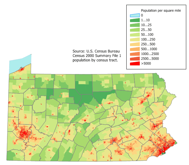
Pennsylvania Population Map USA
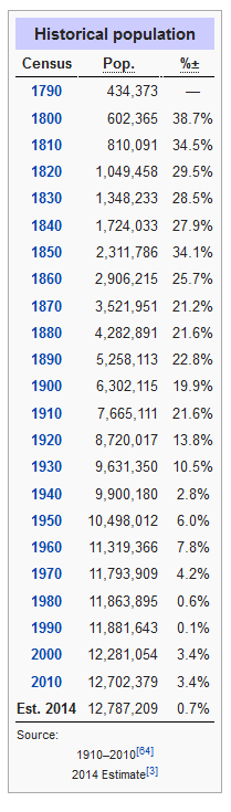
Pennsylvania is 170 miles (274 km) north to south and 283 miles (455 km) east to west. Of a total 46,055 square miles (119,282 km2), 44,817 square miles (116,075 km2) are land, 490 square miles (1,269 km2) are inland waters, and 749 square miles (1,940 km2) are waters in Lake Erie. It is the 33rd largest state in the United States. Pennsylvania has 51 miles (82 km) of coastline along Lake Erie and 57 miles (92 km) of shoreline along the Delaware Estuary.
Largest Cities Map of Pennsylvania and Population
- Philadelphia Map - 1.526.006 - (39.952335, -75.163789)
- Pittsburgh Map - 305.704 - (40.441,-79.996)
- Allentown Map - 118.032 - (40.608,-75.49)
- Erie Map - 101.786 - (42.129,-80.085)
- Reading Map - 88.082 - (40.336,-75.927)
- Scranton Map - 76.089 - (41.409,-75.662)
- Bethlehem Map - 74.982 - (40.626,-75.37)
- Lancaster Map - 59.322 - (40.038,-76.306)
- Levittown Map - 52.983 - (40.155,-74.829)
- Harrisburg Map - 49.528 - (40.274,-76.884)
- Altoona Map - 46.320 - (40.518681, -78.394736)
- York Map - 43.718 - (39.962598, -76.727745)
- Penn Hills Township Map - 42.329 - (40.478781, -79.818468)
- State College Map - 42.034 - (40.793395, -77.860001)
- Wilkes Barre Map - 41.498 - (41.245915, -75.881308)
- Norristown Map - 34.324 - (40.121497, -75.339905)
- Chester Map - 33.972 - (39.849557, -75.355746)
- Mount Lebanon Township Map - 33.137 - (40.372771, -80.047904)
- Bethel Park Map - 32.313 - (40.327570, -80.039498)
- Radnor Township Map - 31.531 - (40.028344, -75.368307)
Where is Pennsylvania in the US and Cities Map of Pennsylvania
Please subscribe on "World Guide" channnel on Youtube at youtube.com/c/WorldGuide
Author: Arif Cagrici- Head of Performance Marketing
- Head of SEO
- Linkedin Profile: linkedin.com/in/arifcagrici
- Head of Performance Marketing
- Head of SEO
- Linkedin Profile: linkedin.com/in/arifcagrici
Google Map, Street Views, Maps Directions, Satellite Images
WorldMap1.com offers a collection of map, google map, atlas, political, physical, satellite view, country infos, cities map and more map of .