

Turkey Earthquake History Map: Major Earthquakes from 1114 to 2023
Turkey has experienced some of the most powerful and destructive earthquakes in history. From the ancient cities of Anatolia to modern Istanbul, Izmir, and Kahramanmaras, major earthquakes have repeatedly transformed communities, landscapes, and the course of history.
Why does Turkey experience so many earthquakes? Which regions have suffered the strongest tremors? And what can centuries of seismic activity tell us about the country's geological future?
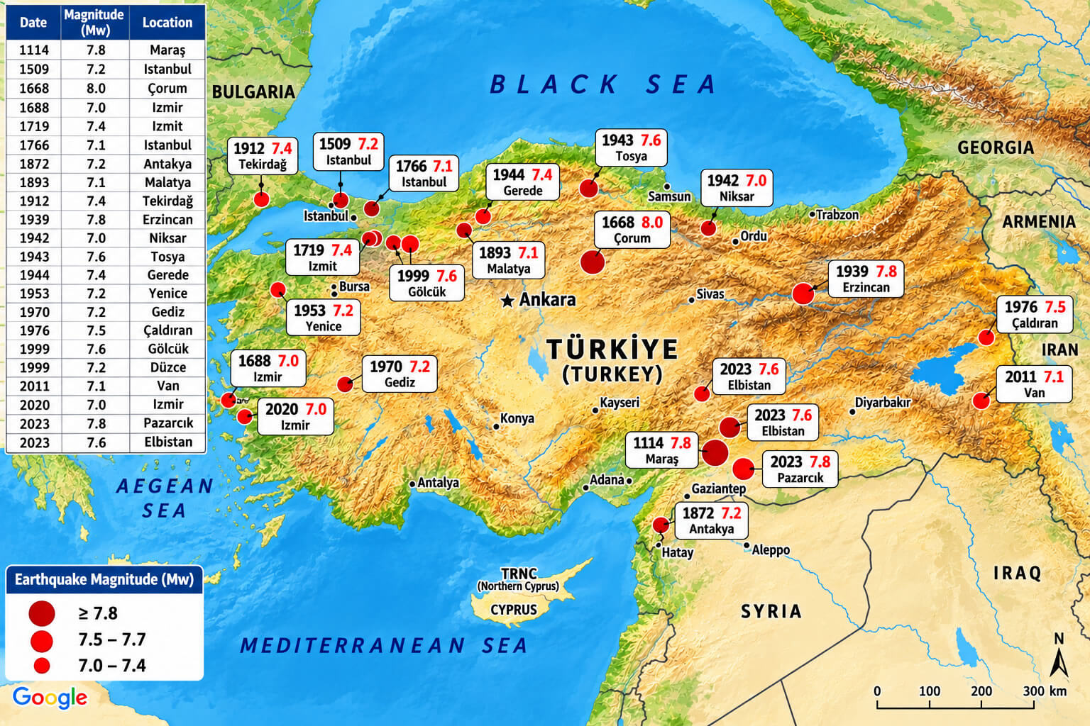
Our Turkey earthquake history map explores major historical earthquakes across Türkiye, highlighting their approximate locations, reported magnitudes, and dates. The map covers events from the devastating 1114 Marash earthquake to the catastrophic February 2023 earthquakes in southeastern Turkey.
Why Is Turkey So Prone to Earthquakes?
Turkey lies at one of the world's most geologically active crossroads, where the Anatolian, Eurasian, Arabian, and African tectonic plates interact. The movement of these massive sections of Earth's crust creates enormous pressure along fault systems. When accumulated stress is suddenly released, an earthquake occurs.
Two major fault systems dominate the country's seismic geography: the North Anatolian Fault, stretching across northern Turkey toward the Sea of Marmara, and the East Anatolian Fault, extending through eastern and southeastern Anatolia. Western Turkey and the Aegean region also contain numerous active faults associated with crustal extension.
These geological conditions help explain why earthquakes have repeatedly struck cities such as Istanbul, Erzincan, Izmit, Van, and Kahramanmaras throughout history.
Major Earthquakes in Turkey: Historical Timeline
Explore the historical earthquakes marked on the map below. Click any year to expand the details and discover what happened, where the earthquake occurred, and why the event matters.
1114 – Marash Earthquake | Historical magnitude uncertain
In November 1114, a devastating earthquake struck the region surrounding Marash, present-day Kahramanmaras, and affected settlements across northern Syria and southeastern Anatolia. Medieval accounts describe widespread destruction, including collapsed buildings and damaged fortifications. The earthquake is among the earliest major seismic disasters documented in the region. Although the map assigns a magnitude of 7.8, no instrumental measurement exists, and modern estimates remain uncertain.
1509 – Istanbul Earthquake | Estimated M 7.2
On September 10, 1509, a powerful earthquake devastated Constantinople, today's Istanbul, during the Ottoman Empire. Remembered in historical accounts as the "Little Judgment Day," the disaster damaged homes, city walls, mosques, and other major structures. A tsunami was also reported in the Sea of Marmara. The earthquake demonstrated the destructive potential of the Marmara region, where the North Anatolian Fault continues to pose a major seismic hazard.
1668 – North Anatolian Earthquake | Estimated M 8.0
The 1668 North Anatolian earthquake was one of the largest known historical earthquakes along the North Anatolian Fault. It affected a broad region of northern Anatolia, with severe damage reported around Bolu, Amasya, and neighboring settlements. Its estimated magnitude is commonly placed near 8.0, although historical uncertainty remains. The event illustrates how a major fault rupture can affect communities hundreds of kilometers apart. The map's association with Corum should not be interpreted as a precisely established epicenter.
1688 – Izmir Earthquake | Historical magnitude uncertain
In 1688, a destructive earthquake struck Smyrna, now known as Izmir, an important commercial port on Turkey's Aegean coast. Historical accounts describe severe damage to buildings, fires, and disruption to the city's commercial activity. The disaster reflects the seismic vulnerability of western Anatolia, where numerous active faults cross the Aegean region. The map lists magnitude 7.0, but historical magnitude estimates vary.
1719 – Izmit Earthquake | Estimated M 7.4
The earthquake of May 1719 struck the eastern Sea of Marmara and Izmit region, causing serious destruction in settlements near the Gulf of Izmit. The event is associated with the North Anatolian Fault system and demonstrates that damaging earthquakes affected the densely populated Marmara region long before modern industrial development. Its estimated magnitude is approximately 7.4, although the exact rupture characteristics remain subject to historical reconstruction.
1766 – Istanbul and Marmara Earthquakes | Approximately M 7+
In 1766, the Marmara region experienced two major earthquakes, one in May and another in August. The May earthquake caused extensive damage in Istanbul, including to religious buildings, homes, and infrastructure, and generated a tsunami. These events are particularly important in studies of earthquake recurrence beneath the Sea of Marmara. The map's single 1766 entry simplifies a sequence of separate earthquakes whose magnitudes and rupture locations are still studied.
1872 – Antakya Earthquake | Historical magnitude uncertain
The April 1872 earthquake devastated parts of the Amik Valley and Antakya region, historically known as Antioch. The disaster damaged settlements near the modern Turkey-Syria border and is associated with the complex fault systems connecting southeastern Anatolia and the Levant. It remains an important historical example of seismic risk in Hatay, a region that would again experience catastrophic shaking during the 2023 earthquake sequence.
1893 – Malatya Earthquake | Estimated M 7.1
In March 1893, a major earthquake struck the Malatya region of eastern Anatolia. The shaking destroyed buildings and caused substantial losses in communities where traditional masonry construction was especially vulnerable. The event is part of the historical seismic record of the East Anatolian region and highlights the long-established earthquake hazard affecting Malatya and surrounding provinces.
1912 – Murefte–Sarkoy Earthquake, Tekirdag | Approximately M 7.3–7.4
On August 9, 1912, a powerful earthquake struck the western Marmara region, particularly the Murefte and Sarkoy areas of Tekirdag province. The earthquake ruptured part of the Ganos Fault, a western section of the North Anatolian Fault system, damaging villages and towns across Thrace. Its documented surface rupture makes it an important event for understanding the seismic history of the Marmara region.
1939 – Erzincan Earthquake | Approximately M 7.8–7.9
On December 27, 1939, one of the deadliest earthquakes in modern Turkish history struck Erzincan. The earthquake caused widespread destruction across northeastern Anatolia and killed approximately 33,000 people. It ruptured a long section of the North Anatolian Fault and became a landmark event in Turkish earthquake science. The disaster also marked the beginning of a remarkable series of major twentieth-century ruptures progressing westward along the fault system.
1942 – Niksar–Erbaa Earthquake | Approximately M 7.0
The December 1942 Niksar–Erbaa earthquake struck northern Anatolia along the North Anatolian Fault. It caused major destruction in the Tokat region, particularly around Erbaa and Niksar. The earthquake followed the devastating 1939 Erzincan event and contributed to the sequence of major ruptures that reshaped scientific understanding of fault activity across northern Turkey.
1943 – Tosya–Ladik Earthquake | Approximately M 7.6
On November 27, 1943, a major earthquake struck the Tosya–Ladik section of the North Anatolian Fault, affecting communities across northern Turkey. Thousands of people lost their lives, and numerous villages experienced extensive destruction. The earthquake formed another major link in the sequence of twentieth-century North Anatolian Fault ruptures, demonstrating the ability of neighboring fault segments to produce devastating earthquakes within a relatively short period.
1944 – Bolu–Gerede Earthquake | Approximately M 7.4
The February 1, 1944 Bolu–Gerede earthquake struck northwestern Anatolia and caused severe destruction along a large section of the North Anatolian Fault. The earthquake produced extensive surface rupture and damaged settlements across the Bolu and Gerede region. Scientists continue to study this event because it provides important evidence of how large strike-slip faults rupture and transfer stress between neighboring sections.
1953 – Yenice–Gonen Earthquake | Approximately M 7.2
On March 18, 1953, a powerful earthquake struck the Yenice–Gonen region of northwestern Turkey, near the southern Marmara area. The disaster caused widespread structural damage and loss of life, especially in rural settlements. Its surface rupture helped researchers better understand the active fault systems south of the Sea of Marmara, an area with a long history of destructive earthquakes.
1970 – Gediz Earthquake | Approximately M 7.2
On March 28, 1970, a destructive earthquake struck Gediz in Kutahya province, western Turkey. The disaster caused severe damage to homes and public buildings, killed more than a thousand people, and led to major reconstruction and relocation efforts. Unlike the major northern Anatolian earthquakes, the Gediz event occurred within western Turkey's complex extensional fault environment, highlighting the country's diverse earthquake hazards.
1976 – Caldiran–Muradiye Earthquake | Approximately M 7.3–7.5
On November 24, 1976, a devastating earthquake struck the Caldiran–Muradiye region of Van province in eastern Turkey. Thousands of people died, and many villages were destroyed or severely damaged. Harsh winter conditions complicated rescue and relief operations. The event demonstrated the vulnerability of remote mountain communities to major earthquakes and the importance of earthquake-resistant construction throughout eastern Anatolia.
1999 – Izmit–Golcuk Earthquake | Approximately M 7.4–7.6
On August 17, 1999, a devastating earthquake struck the Izmit and Golcuk region, close to Turkey's heavily industrialized Marmara coastline. The earthquake caused widespread building collapses, major infrastructure damage, and more than 17,000 deaths. Its proximity to Istanbul intensified concerns about seismic risk in the country's largest metropolitan area. The disaster became a turning point in public awareness of building safety, emergency preparedness, and earthquake engineering in Turkey.
1999 – Duzce Earthquake | M 7.2
On November 12, 1999, less than three months after the Izmit disaster, another major earthquake struck near Duzce in northwestern Turkey. The magnitude 7.2 earthquake caused additional destruction across a region already recovering from the August earthquake. It demonstrated how closely spaced major earthquakes can occur on adjacent sections of an active fault system. The original map incorrectly labels this Duzce earthquake as a 2020 event.
2011 – Van Earthquake | Approximately M 7.1–7.2
On October 23, 2011, a powerful earthquake struck Van province in eastern Turkey, causing severe destruction in Van and Ercis. Hundreds of people died, and thousands of buildings were damaged or destroyed. The earthquake occurred in a region shaped by the continuing collision of the Arabian and Eurasian plates. The disaster highlighted the dangers of vulnerable buildings and the challenges of providing shelter during cold weather.
2020 – Aegean Sea–Izmir Earthquake | Approximately M 7.0
On October 30, 2020, a major earthquake occurred in the Aegean Sea near the Greek island of Samos and Turkey's Izmir province. The shaking caused serious building collapses in Izmir, particularly in the Bayrakli district, while tsunami waves affected coastal settlements in both Turkey and Greece. The event showed that offshore earthquakes can threaten densely populated coastal cities far from the earthquake's epicenter.
2023 – Pazarcik–Kahramanmaras Earthquake | M 7.8 (USGS)
At 4:17 a.m. local time on February 6, 2023, a catastrophic earthquake struck southeastern Turkey near Pazarcik in Kahramanmaras province. The magnitude 7.8 earthquake ruptured a large section of the East Anatolian Fault system, causing widespread destruction across southern Turkey and northern Syria. Entire neighborhoods suffered building collapses, transport networks were damaged, and communities faced an enormous humanitarian disaster. The event became one of the most destructive earthquakes in Turkey's modern history.
2023 – Elbistan Earthquake | M 7.5 (USGS), M 7.6 (AFAD)
Approximately nine hours after the first catastrophic earthquake on February 6, 2023, another powerful earthquake struck near Elbistan in Kahramanmaras province. This second major event ruptured a separate fault system and caused additional destruction across an already devastated region. Its magnitude was reported as 7.5 by the USGS and 7.6 by Turkey's AFAD. Together, the two earthquakes created an extraordinary disaster that affected millions of people and demonstrated the complexity of interconnected fault systems.
What Was the Strongest Earthquake in Turkey's History?
Among Turkey's best-documented modern earthquakes, the 1939 Erzincan earthquake stands out with an estimated magnitude of approximately 7.8–7.9. The 2023 Pazarcik earthquake, measured at magnitude 7.8 by the USGS, was similarly powerful.
Historical earthquakes, including the 1668 North Anatolian event, may have reached magnitude 8.0 or higher according to some reconstructions. However, comparing pre-instrumental estimates with modern measurements requires caution because the available evidence and methods differ.
Which Parts of Turkey Have the Highest Earthquake Risk?
Earthquake hazards vary considerably across Turkey. Several regions deserve particular attention because of their proximity to major active faults:
- Istanbul and the Marmara region: Exposed to major earthquake hazards associated with the North Anatolian Fault and its offshore segments.
- Erzincan, Bolu, and northern Anatolia: Located along or near sections of the North Anatolian Fault with a long history of major earthquakes.
- Kahramanmaras, Hatay, and Malatya: Affected by the East Anatolian Fault system and neighboring active structures.
- Izmir and the Aegean region: Exposed to earthquakes from active onshore and offshore faults.
- Van and eastern Anatolia: Subject to complex faulting associated with regional tectonic compression.
Earthquake hazard does not automatically determine the level of damage. Building quality, local soil conditions, population exposure, infrastructure, and preparedness all influence the consequences of a major earthquake.
Frequently Asked Questions About Earthquakes in Turkey
Why does Turkey have so many earthquakes?
Turkey is located near the boundaries of several interacting tectonic plates. Their movement creates stress along active fault systems, particularly the North Anatolian and East Anatolian faults, as well as numerous faults in the Aegean region.
What was the deadliest earthquake in modern Turkish history?
The February 2023 Kahramanmaras earthquake disaster caused more deaths than any other earthquake disaster in modern Turkish records. The 1939 Erzincan earthquake, which killed approximately 33,000 people, was another exceptionally deadly event.
Is Istanbul at risk of a major earthquake?
Yes. Istanbul is close to active segments of the North Anatolian Fault beneath the Sea of Marmara. Historical earthquakes, geological studies, and seismic monitoring confirm that the region faces significant earthquake hazards, although the timing of a future major event cannot be predicted precisely.
What happened during the February 2023 Turkey earthquakes?
On February 6, 2023, a magnitude 7.8 earthquake struck near Pazarcik, followed approximately nine hours later by a magnitude 7.5 earthquake near Elbistan, according to the USGS. The two events caused catastrophic destruction across southern Turkey and northern Syria.